Someone recently pointed out to me that it’s been 4,261 days since I first started at Essex County Council (pause for shocked gasps).

So, it’s been a while since I’ve thought much about my days walking to school. Or at least it was, until I embarked upon a project with our wonderful Sustainable Travel Planning team to support planning for Healthy School Streets. Delving into the topic I realised just how much impact journeys to school have, not just for the pupils themselves but for their families, local residents, traffic conditions… these daily journeys have a ripple effect across the whole community.
What Are Healthy School Streets?
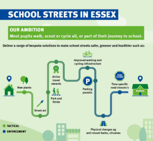
The Healthy School Street approach aims to improve the street environment, making it easier for students to walk, wheel, and cycle to school. It's a human-centred framework for street planning and aims to make streets healthy and safe places for everyone through interventions such as crossings, 20mph speed limits, trees and barriers, signs and street art (among many other options).
As you can imagine this approach supports a plethora of benefits including:
· Safer travel for children and families/carers to school
· Increased active travel and improved child health
· Reduced traffic and illegal parking
· Lower air pollution around schools
· Quieter neighbourhoods
· Enhanced road safety, both perceived and real
· Public infrastructure improvements, such as cycle parking, benches, and lighting.

The Data Ask
With around 560 schools in Essex, resource constraints require a targeted approach to prioritise where these interventions can be most effective. Our task was to develop a tool using available data to identify where Healthy Streets interventions could be most effective and have a positive impact on the maximum number of pupils.
The Tool
The Healthy School Streets Prioritisation Tool was developed with five main aims in mind:
1. Visualising Information: Bringing relevant information into one place
2. Ease of Comparison: Making it easy to find details for multiple schools and compare them
3. Adding Context: Incorporating contextual information about each school, such numbers of nearby collisions and the name of their local councillor
4. Prioritisation: Building in options for prioritisation and ranking to support shortlisting
5. Supporting Planning and Decision Making: Providing information to complement the teams and support decision-making.
Throughout the project the value and importance of having local knowledge from the Sustainable Travel Planning team alongside the data was really evident. For instance, when mapping schools into geographical groups we used a combined approach - identifying draft groupings by radius and street address, and then layering with knowledge of the area and roads which helped to give much more accurate insight.
What’s Next?
The team is now using the tool to explore the details and support a shortlisting process for the next stage of planning. Moving into phase two involves further information gathering and beginning early engagement work focused on a shortlist of around 10-15 schools identified as potentially suited for interventions.
The Healthy School Streets work is a really worthwhile programme and it’s great when we, as a data team, can join forces and create data solutions that complement the knowledge and expertise in various teams. It's even more satisfying when we can see the potential for our work to contribute to efforts to make positive change in Essex. Together, we’re making strides towards healthier, safer school streets for everyone.